Smartphone apps can help drivers navigate traffic congestion
- Share via
Labor Day is almost here, and you know what that means: the end of summer and a whole lot more traffic.
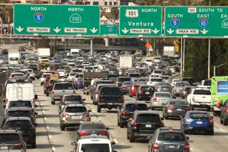
But don’t despair. Your smartphone can help ease you through this time of traffic transition. With the right app, you can turn your iPhone or Android phone into a potent weapon to fight the onslaught of back-to-work highway congestion.
If, like me, you have no sense of direction and have lost your Garmin, I highly recommend Waze — a free app that helps users avoid traffic and gives verbal directions like the Garmin car navigation device.
Waze’s interface is excellent. Street names are easy to read and your vehicle’s location is clearly marked with a blue arrow.
It’s also an easy app to use. Type in the address of where you want to go and Waze will calculate the fastest route from your current location, taking into account traffic information from other Waze users who are driving in your area. It uses geo-location technology that tracks the location and speed of Waze users. You can see the other Waze-using drivers on your device map.
Because Waze’s traffic information is crowd-sourced, it works better when more people use it. Here in Los Angeles, we’re lucky. Waze has 800,000 users in L.A., which means there is a 1 in 10 chance that the driver next to you is using Waze too.
In Israel, where the company was founded, Waze users are even luckier. About 30% of registered drivers use Waze there.
Waze users can also report traffic jams, accidents on the side of the road and even hidden police cars. Reports of these traffic conditions will then show up on everyone’s Waze maps while they’re driving. If you’re behind the wheel, you can wave your hand over the phone and verbally report what you see on the road.
My father recently used Waze to direct a cabdriver who was taking him from the Long Beach Airport to my house near downtown Los Angeles. The cabdriver told my dad that the Waze route easily shaved 20 minutes off the ride.
Another popular app is Inrix Traffic. Whereas Waze has a fun, “We’re part of a driving community” feel, Inrix Traffic is all business. The free version of the app, available for both the iPhone and Android devices, works best if you want to know before you start driving whether it is better to take the 710 or the 605 to get to work.
Using your current location, Inrix Traffic automatically suggests two routes to a location you’ve selected. The app gives you the estimated length of time for each of the two suggested routes. You also have the option of sharing your estimated time of arrival via text or email with someone who might be waiting for you.
Unlike Waze, Inrix’s free app does not automatically give users step-by-step directions. Also, you can store only two locations in the free version of the app. That’s fine if you use it exclusively for your commute between home and work. But if you also want to know how long it will take you to get to your kid’s school, you will be asked to upgrade to a premium version of the app for $24.99.
If all you want is a quick glance at traffic conditions, consider checking out the SigAlert app for iPhones. This free app gives you detailed information on how fast the freeways and roads around you are moving, as well as real-time information on broken-down vehicles that might be blocking lanes on your usual route. It provides much more traffic detail than Google’s free traffic map.
For those who want to use these apps while driving, I’d recommend getting a dashboard or windshield mount for the phone. You don’t want to be the one slowing traffic.
More to Read
Inside the business of entertainment
The Wide Shot brings you news, analysis and insights on everything from streaming wars to production — and what it all means for the future.
You may occasionally receive promotional content from the Los Angeles Times.


