Our wacky weather: From record heat to snowfall as first storm of season rolls in

- Share via
The first storm of the season is set to roll into Southern California this week, bringing rain and the potential for snow at higher elevations. But the area isn’t completely in the clear for fire danger, weather officials said Monday.
Starting Tuesday night, the Los Angeles area is expected to see about half an inch of rain, with the San Gabriel Valley foothills and mountains getting a stronger downpour, said Andrew Rorke, a meteorologist with the National Weather Service in Oxnard.
“It’s kind of funny to have the weather change so quickly,” Rorke said, noting that temperatures Monday will still be in the low 90s, keeping fire danger elevated. On Sunday, several areas hit record temperatures, with Los Angeles International Airport reaching 93 degrees and Santa Barbara recording 85 degrees, according to the weather service.
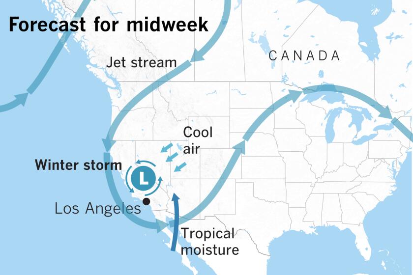
A low-pressure system that developed in Northern California is descending into the Southland, releasing water it picks up from the ocean as it makes its way down the state.
By Wednesday, the mercury will drop into the 60s, and rain is expected to arrive across the entire region — from the coasts to the valleys, Rorke said. Nearby ski resorts at an elevation of 5,500 feet or higher should get their first snowfall, with 3 to 6 inches of powder predicted.
In the burn zones of the recent Getty and Barham fires, residents should be aware of the potential of mudslides, which the rainy season could bring, forecasters warned. Rorke, however, said this week’s rain probably wouldn’t be strong enough to cause mudslides in burned-out areas. There also had been reports of potential flash flooding with this storm, but Rorke said that risk had subsided.
“We have to be aware of the recently burned areas,” he said. “But it’s not a great concern right now.”
The few days of rain won’t be enough to erase the fire threat across Southern California. By the weekend, the weather will become dry and sunny again, bringing the potential for more fire danger, Rorke said.
Beneficial rain with a low risk of flash flooding is predicted for Tuesday through Thursday in Southern California
The same low-pressure system that’s bringing rain to the L.A. area is creating an offshore wind event in Northern California, increasing the risk of fires there.
Winds will reach 30 to 55 mph, and humidity levels will be quite low, especially Wednesday, according to the National Weather Service.
The areas surrounding Sacramento — including the Sacramento Valley and Yuba, Butte, Yolo and Solano counties — are under a fire weather watch from Tuesday night through Thursday morning, as are the areas above 1,000 feet near the North Bay Mountains, East Bay Hills and the Diablo Range.
As a result, Pacific Gas & Electric Co. may turn off power to 250,000 customers in parts of 19 counties, including the Sierra foothills and North Bay Area, by midweek.
As of Monday morning, the utility had not decided whether it would move forward with the public safety power outage. Affected residents will be notified later in the day, PG&E said.
More to Read
Sign up for Essential California
The most important California stories and recommendations in your inbox every morning.
You may occasionally receive promotional content from the Los Angeles Times.


