Much-needed Southern California rain is on the way after this week’s heat wave

- Share via
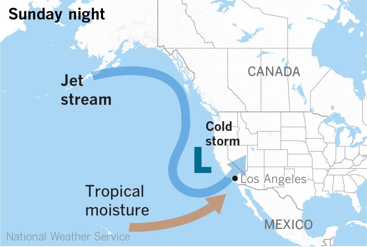
A cold Pacific storm is expected to bring dramatic change to Southern California’s weather Sunday night into Tuesday, forecasters say.
After temperatures this week reached the upper 80s to 90s, breaking several record daily highs, a strong, cold, upper-level low-pressure system will drop down along the California coast, according to the National Weather Service. The storm will tap into tropical moisture from an atmospheric river, bringing significant rain and wind.
High temperatures will nosedive, dropping by 10 to 15 degrees. Precipitation is expected to begin Sunday night and to last through Monday night, possibly into early Tuesday. Rain could be heavy at times Monday afternoon and evening.
Forecasters say precipitation totals will range from half an inch to 1½ inches in the coasts and valleys, and between 1 and 3 inches in the foothills and mountains, with the heaviest precipitation on south-facing slopes, especially in the eastern San Gabriel Mountains. The Antelope Valley can expect up to three-quarters of an inch. Snow will accumulate at elevations above 6,000 feet and could be significant above 7,000 feet, the weather service said.
A quarter-inch to a half-inch of rain is forecast to fall per hour, with some heavier rates during downpours Monday afternoon and evening. Minor mud and debris flows are possible near recent burn scars in L.A. and Santa Barbara counties. Gusty winds are expected Sunday through Monday, lingering until Tuesday in the mountains.
After a record-dry start to 2022, California water officials have slashed State Water Project allocations from 15% to 5%.
The rain will be “beneficial,” according to Alex Tardy, a meteorologist with the National Weather Service in San Diego. “It will buy us some time into the spring,” he said, “so we don’t have to worry as much about fire-weather dry conditions due to the expanding drought.”
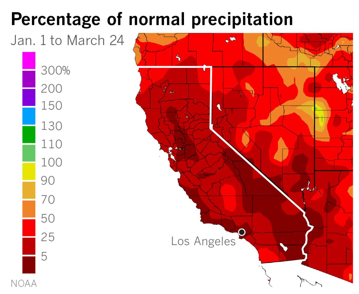
Most parts of California have received less than 20% of normal precipitation for the calendar year, and the snowpack has dwindled to half what it should be, after starting the year at 150%.
Both a lack of snowfall and warm temperatures during record-dry winter months have contributed to the snowpack’s disappearance. Much of California is between 50% and 75% of normal precipitation for the water year, which began Oct. 1, and persistent upper-level high pressure has kept temperatures unusually warm across the state, especially in the mountains, speeding up the snowmelt.

Next week’s storm, Tardy said, will dive far enough south to tap into a solid atmospheric river to give a boost to rainfall amounts. In that respect, it’s similar to a handful of storm systems that hit the state in December, he said.
A strong upper low can be all it takes to produce an inch of rain at the coast if atmospheric conditions are unstable, which occurs when there is enough cold air aloft.
The weather pattern in California this winter has been dominated by a strong upper ridge of high pressure, repelling storm systems that have been too weak to break through. The ridge of high pressure, which Tardy says has been mostly in place since early 2019, is an atmospheric feature of La Niña and how it affects the jet stream.
“I think this current Monday storm system is part of a large Gulf of Alaska-Aleutian series of upper lows,” Tardy said. It is strong enough to push into the West Coast and has enough wind energy to drive it down to Southern California.
Tardy expects the ridge of high pressure to recover and deflect the next two systems into the Pacific Northwest and western Canada, but he said Monday’s storm setup might be repeated about a week into April.
More to Read
Sign up for Essential California
The most important California stories and recommendations in your inbox every morning.
You may occasionally receive promotional content from the Los Angeles Times.


