

- Share via
Cold gray storm clouds swirled over Phillips Station near South Lake Tahoe on Thursday as state officials trudged through fresh powder to conduct their third snow survey of the season — just hours before a monster blizzard was set to dump up to 12 feet of snow across the Sierra Nevada.
“It is significantly colder than it was a month ago, and that is indicative of the big storm system that we have coming in that will likely bring lots of rain and lots of snow, which is good for our snowpack,” said Sabrina Washington, an information officer with the California Department of Water Resources.
Aggressive and impactful reporting on climate change, the environment, health and science.
Even without the incoming storm, the state’s snowpack has shown a considerable turnaround since the start of the year, when it measured just 28% of normal and sparked worries of a developing “snow drought.”
As of Thursday, statewide snowpack measured 80% of normal for the date, with a snow water equivalent of 18.7 inches. Snowpack was about 70% of its average for April 1, the date when it is typically at its deepest.

“We have built really nicely — we just got a late start,” said Andy Reising, water resources engineer with the DWR’s snow survey and supply forecasting unit. “We’re hoping we can capture more in the coming month.”

Indeed, the current wet season started slow, with little precipitation in November and December. Many of the storms that pounded California in January and February were warmer than usual — delivering more rain than snow — and often fell in the southern parts of the state. (February was among the wettest on record in Los Angeles, with 12.66 inches of rain in downtown L.A.)
But officials were optimistic the looming blizzard could offer a significant snow boost.
“The good news is that we have a big storm starting here through the weekend, and it will be a cold one,” Reising said, noting that heaps of powder are expected at both high and low elevations along the Sierra. “We’re quite pleased to announce that that’s coming, and it will help get us toward average, or maybe above average, for the state.”
The National Weather Service has issued urgent storm advisories warning of the strongest Sierra storm of the season. Up to 12 feet of snow could fall on the highest peaks through Sunday, while areas with an elevation of 5,000 feet or higher could get 5 to 10 feet.
The NWS has also issued wind advisories and avalanche watches throughout the region.
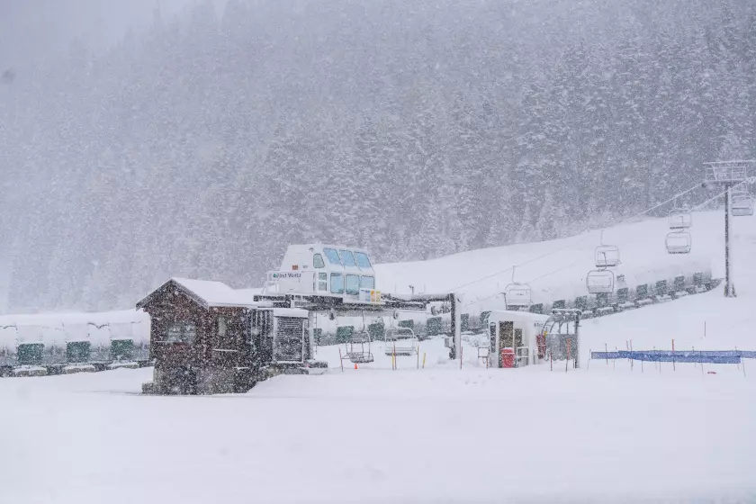
A treacherous, life-threatening blizzard hitting Lake Tahoe and Mammoth is expected to peak Friday night into Saturday. Yosemite National Park was ordered shut.
But though snowpack has shown some growth, more will be needed to reach 100% of normal for the year, DWR officials said. They will be keeping close watch on weather forecasts and runoff potential in the days and weeks ahead.
“We are now in the last month of the traditional snow season, and while conditions have dramatically improved since the beginning of the year, March will be critical in determining if we finish above or below average,” read a statement from director Karla Nemeth. “No matter how the season ends, we are ready to take advantage of the water we do have to benefit communities, agriculture, and the environment, and continue storing stormwater in our groundwater basins for future use.”

The slow start to the year has resulted in some uncertainty about water supplies moving forward, as snowpack typically accounts for about a third of California’s supply in a given year.
Last month, the DWR predicted it could allocate 15% of requested supplies to the State Water Project, which provides water to 29 agencies serving 27 million people.
But that allocation could go up if the incoming blizzard delivers on its promise, said Molly White, water operations manager with the State Water Project.
“We have seen an improvement in the conditions and ... will be crunching our numbers to reassess the allocation in March,” she said.
The storm is almost certain to pack a wallop, said Daniel Swain, a climate scientist with UCLA. During a briefing Thursday, he noted that the system is somewhat unusual for its frigid temperatures and wet conditions. It is rare to see such a cold air mass that is also moist and associated with so much storm activity, he said.
“The one part of the state that hasn’t been as wet as had hoped for this point in the season is the Sierra Nevada,” Swain said.
“All of that is going to change dramatically over the next 48 hours with feet of snow just about everywhere,” he said. “You will not be measuring in inches but rather feet at almost all locations above 3,000 or 4,000 feet, so this will be an event that produces heavy to extremely heavy snowfall, even at elevations that have struggled so far this season to see meaningful accumulations.”
The storm could set top-five daily or two-day snow accumulation records in some locations, he said. Snowfall rates of 2 inches per hour — or even up to 5 inches per hour — are possible for multiple hours on end, he said, with totals between 50 and 100 inches in some places.
“This will be another snowstorm probably for the record books in some places,” Swain said. “And so when all is said and done, it’s quite likely that Sierra snowpack will be significantly above average just about everywhere in as little as a week.”

Storms in February have significantly boosted California’s snowpack, giving the state near-average conditions and ample water supplies.
However, David Rizzardo, the DWR’s hydrology section manager, cautioned that one storm does not a season make. He said the latest projections show that runoff from melting snow could still land below average this spring and summer because of the “extremely dry and warm fall” that kicked off the water year.
The snow runoff projections help water managers and reservoir operators know how much will be available for use later in the year.
“The good news is we should see these numbers come up — hopefully much closer to average or even slightly above average — but we still have to have March,” Rizzardo said.
Surface water storage in California’s major reservoirs is currently 119% above average, state data show. The latest seasonal outlooks from the National Oceanic and Atmospheric Administration are unclear about what March, April and May could hold for California, with equal chances of wet or dry conditions.
Even as officials celebrated a potential boost to the state’s water supply, they also cautioned about the dangers of the incoming blizzard.
“This upcoming storm is going to cause significant impacts across the Sierra Nevada, and it’s going to make travel nearly impossible,” said state hydro-meteorologist Angelique Fabbiani-Leon. “We want to remind the public: Do not travel to the Sierra Nevada this upcoming weekend.”


More From the Los Angeles Times


Podcasts

Many Altadena & Pacific Palisades residents can’t afford to rebuild. What will this displacement mean for their communities?

Trump’s new budget guts federal solar/wind aid, favoring fossil fuels. Sammy Roth talks with Jesse Jenkins about its potential to worsen climate pollution & raise energy costs.

