Santa Barbara’s Rattlesnake Canyon
- Share via
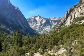
Rattlesnake Canyon Trail is serpentine, but otherwise far more inviting than its name suggests.
This trail explores Santa Barbara’s next-door wilderness. It’s a delightful hike year-round.
The joys of Rattlesnake Canyon were first officially promoted by the Santa Barbara Chamber of Commerce. Many a turn-of-the-century visitor to Santa Barbara resorts enjoyed hiking and riding in the local mountains. Eager to keep the customers satisfied, in 1902 the chamber purchased easements from canyon homesteaders to develop a recreation trail.
An Immediate Success
“Chamber of Commerce Trail,” as the chamber enthusiastically called it, was an immediate success with tourists and locals. However, to the chamber’s consternation, both the trail and the canyon itself continued to be called Rattlesnake. Chamber of Commerce Canyon sounded a bit stuffy, so the chamber tried to compromise with an earlier name, Las Canoas Canyon, and adopted a 1902 resolution to that effect. “The name of Rattlesnake Canyon is unpleasantly suggestive of a reptile,” it argued, “which is found no more plentifully there than elsewhere along the mountain range and may deter some nervous persons from visiting that most delightful locality.”
In the 1960s, the City of Santa Barbara purchased the canyon as parkland. A handsome wooden sign at the foot of the canyon now proclaims: Rattlesnake Canyon Wilderness.
Directions to trail-head: From U.S. 101 in Santa Barbara, go uptown (toward the mountains) on State Street to Los Olivos Street. Turn right and proceed half a mile, passing by the Santa Barbara Mission and joining Mission Canyon Road. Follow Mission Canyon Road past its intersection with Foothill Road and make a right on Las Canoas Road. Follow Las Canoas Road to Skofield Park. Park on the road or in the large parking area just before the picnic grounds. The trail begins on Las Canoas Road near the handsome stone bridge that crosses Rattlesnake Creek.
The Hike: From the sandstone bridge across from Skofield Park, hike up a brief stretch of trail and join a narrow dirt road that parallels the east side of the creek. For lovely picnicking, take any of the steep side trails down to the creek. In the early 19th Century, mission padres built a dam in the bottom of the canyon which channeled water into a stone aqueduct and diverted it into the mission’s waterworks system. Portions of the aqueduct can be seen by the careful observer.
A Reflecting Pool
The trail crosses to the west side of the creek and passes through a tiny grove of Monterey pine planted by the Sierra Club after the Coyote Fire of 1964. Next it switchbacks up the canyon wall and again parallels the creek. As the canyon narrows, you’ll pass a tranquil pool that captures an oak’s reflection and yours.
The trail zigs and zags across the creek, finally continuing along the west bank to open, grassy Tin Can Meadow. The triangular-shaped meadow gets its name from a homesteader’s cabin constructed of chaparral framing and kerosene can shingles and sidings. For the first quarter of this century, Tin Can Shack was an important canyon landmark and several guidebooks of that era mention it. It was a popular destination for picnickers who marveled at the inspired architecture and posed for pictures in front of it. In 1925, a brush fire destroyed the shack and it soon disintegrated into a pile of tin. Today, only faint traces of the shack’s foundation can be seen in the meadow, although when the angle of the morning sun is just right, hikers swear they can see bits of tin glinting.
Option: Return the same way or, if you’re feeling energetic, hike on toward the apex of the triangular meadow where you’ll find a trail junction. The trail bearing left takes you three-quarters of a mile and climbs 500 feet to its intersection with the Tunnel Trail--and incidentally to many points of interest in the Santa Barbara back country. To the right, Rattlesnake Canyon Trail climbs about three-quarters of a mile and 500 feet to its intersection with Gibraltar Road. There you will be greeted by an unobstructed view of the South Coast. Watch for strangely patterned triangular aircraft overhead. A favorite hang glider’s launching peak is almost within reach.
Return the same way.
RATTLESNAKE CANYON TRAIL: Skofield Park to Tin Can Meadow: 4.5 miles round - trip, 1,000-foot gain in elevation.
Skofield Park to Gibraltar Road: 6 miles round - trip, 1,550-foot gain in elevation.
More to Read
Sign up for The Wild
We’ll help you find the best places to hike, bike and run, as well as the perfect silent spots for meditation and yoga.
You may occasionally receive promotional content from the Los Angeles Times.


