It’s Easy to Get a Good Peek From This Summit
- Share via
Mt. Williamson stands tall above other crests along Angeles Crest Highway. The 8,214-foot peak offers grand views of earthquake country--the Devil’s Punchbowl, San Andreas Fault and the fractured northern edges of the San Gabriel Mountains.
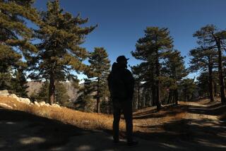
This peak may offer desert views, but Mt. Williamson is anything but a desert peak. It’s plenty green and bristles with pine and fir.
The summit of Mt. Williamson is the high point and culmination of well-named Pleasant View Ridge, a chain of peaks that rises from the desert floor to Angeles Crest Highway.
It’s quite a contrast to stand atop the piney peak, which is snow-covered in winter, and look down upon Joshua trees and the vast sandscape of the Mojave Desert.
Hot and cold, desert and alpine environments--these are the contrasts that make hiking in Southern California so special.
The mountain’s namesake is Maj. Robert Stockton Williamson, who first explored the desert side of the San Gabriels in 1853. Williamson, a U.S. Army cartographer, led an expedition in search of a railroad route over or through the mountains.
Williamson found no passable route through the Mt. Williamson area, or any other place in the San Gabriel Mountains high country, but the major did find a way around the mountains, so his mission was definitely a success.
Williamson’s Pacific Railroad Survey report to Congress detailed two railroad routes: Cajon Pass on the east end of the San Gabriels and Soledad Canyon on northwest.
Two fine forest-service trails ascend Mt. Williamson from Angeles Crest Highway. One trail leads from Islip Saddle, the other from another (unnamed) saddle 1 1/2 miles farther west. Both are well-graded, well-maintained routes.
Perhaps, after a glance at a map, the idea of linking the east and west Mt. Williamson trails with a walk along Angeles Crest Highway (in order to make a loop trip) will occur to you. Don’t be tempted.
The problem is that between the two trails, Angeles Crest Highway passes through a couple of tunnels--a definite no-no for pedestrians.
Both Mt. Williamson trails are winners; you can’t go wrong. Mt. Williamson is a great place to beat the heat, and offers fine hiking in all seasons but winter, when snow covers the trail.
Directions to trailhead: From the Foothill Freeway (210) in La Canada, exit on Angeles Crest Highway (2) and drive about 38 miles, or 2 1/2 miles past (east of) the Krakta Ridge Ski Area. Look for the (sometimes) signed trail to Mt. Williamson on the left (north) side of the highway.
The Mt. Williamson East Trail is easier to find. Continue four miles east of the Krakta RidgeSki Area, and after you pass through the highway tunnels, you’ll see the parking area at Islip Saddle on the left (north) side of the highway.
The hike: At Islip Saddle, you’ll spot South Fork Trail (remember this fine trail for another day) heading northeast down to South Fork Camp near Devil’s Punchbowl County Park. But you’ll join the trail to Mt. Williamson and begin ascending through a forest of Jeffrey and ponderosa pine.
Two miles of steep--but not brutal--climbing brings you to a junction with the Mt. Williamson West Trail.
The two trails continue as one, passing scattered white fir (more numerous as you near 8,000 feet in elevation). You’ll enjoy over-the-shoulder views south of Bear Creek Canyon and the heart of the rugged San Gabriel Wilderness.
It’s astonishing to think that this wilderness, just a few miles south of where you’re hiking, is also only 18 miles as the crow flies from downtown Los Angeles.
Keep hiking north on the trail, which gets a little faint as it nears the summit of Mt. Williamson.
From the peak, enjoy the dramatic views of the desert below. If you have a good map along, you can pick out the many playas (dry-lake beds), buttes and mountain ridges of the dry lands below.
At the base of Mt. Williamson is that greatest of earthquake faults--the San Andreas Rift Zone. Most striking of all is the view of Devil’s Punchbowl and its jumbled sedimentary strata.
Remember that this isn’t a loop hike; return the way you came.
Mt. Williamson Trail * WHERE: Angeles National Forest * LENGTH: 5 miles round trip, 1,600-foot elevation gain. * TERRAIN: Mountains, pine forest. * HIGHLIGHTS: Mountain and desert panoramas. * DEGREE OF DIFFICULTY: Moderate. * PRECAUTIONS: Don’t walk on Angeles Crest Highway. * FOR MORE INFORMATION: Call the Angeles National Forest’s Chilao Visitors Center at (818) 796-5541.
More to Read
Sign up for The Wild
We’ll help you find the best places to hike, bike and run, as well as the perfect silent spots for meditation and yoga.
You may occasionally receive promotional content from the Los Angeles Times.


