Road to the Future : Driving: Using high-tech tools such as sensors in the roadway and computers, transit planners hope to unclog jams on the Santa Monica Freeway as they form. If successful, the approach may serve as a model across the country.
- Share via
Now that Los Angeles’ last freeway has been built, transportation officials are turning their attention to a clogged old one--the world’s busiest roadway, in fact.
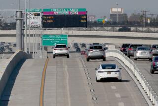
Drivers on the Santa Monica Freeway will soon zoom into a brave new world of high-tech traffic management in a $48-million experiment that may serve as a model for relieving congestion on highways across the country.
Known as the Smart Corridor, the system is designed to spot potential problems as they pop up and to throw a myriad of mitigating measures against them--from the most basic tow trucks to the most sophisticated artificial intelligence.
It amounts to the first step by city and state officials to coordinate efforts against a traffic flow that fills the Santa Monica Freeway with 20% more vehicles than traffic engineers ever thought possible.
With as many as 340,000 trips a day on the Santa Monica, a minor fender-bender can make for a major jam that reverberates down the stream of vehicles, and spills over into surface streets long after the cause has been removed.
The Smart Corridor project was hatched in the wake of the traffic triumph of the 1984 Olympics, when officials used various measures to avoid a feared congestion nightmare on freeways and installed computer-controlled traffic signals around the Los Angeles Coliseum.
A Los Angeles city transportation official decided there was no reason such a miracle could not be achieved in the everyday life of local commuters. Soon, county and state officials signed on in a cooperative effort to use high-tech tools to tackle a whopper of a trouble spot--a thickly congested 14 1/2-mile stretch of Interstate 10 between Downtown Los Angeles and the edge of Santa Monica.
The heart of the Smart Corridor is an electronic system that will read traffic patterns on freeway and surface streets with the help of sensors embedded in the roadway, TV cameras, cellular phone calls and California Highway Patrol officers equipped with computers.
Digesting thousands of bits of data per second, the system will analyze historical traffic patterns and supply managers with scenarios for dealing with the immediate problems, along with closed-circuit television images of the mess, all on the same computer screen.
Then, with the click of a computer mouse, programmed messages will appear on electronic message signs and a low-power radio network, traffic signals will adjust their timing and ramp meters will slow the flow of new cars onto the freeway.
Drivers warned off the freeway will follow newly installed “trailblazer” signs to guide them back on without clogging residential streets.
“It’s like having your best-trained staff there 24 hours a day,” said Alan Clelland, a consultant whose firm is coordinating the project along Interstate 10 and five parallel boulevards: Adams, Washington, Venice, Pico and Olympic.
“And if the operators make the wrong decisions, we’ll plug that in (the computer) so we’ll know in the future,” said Caltrans engineer Lewis W. Yee.
Officials say the price tag is reasonable when compared to the $100-million-per-mile cost of the just-opened Century Freeway. The $48-million Smart Corridor is being funded largely by gasoline tax revenues.
(The name, incidentally, does not stand for “Super-Modern Attempt to Reduce Traffic” or anything like that; planners said they never got around to thinking up an acronym.)
“The hardware, software and sophistication to manage it is costly, but it’s dwarfed by the construction alternatives,” said Wilfred W. Recker, chairman of the Institute for Transportation Studies at UC Irvine.
“It would be a mistake to think technology like the Smart Corridor is a magic pill. It’s not,” he said. “But it’s going to be one more arrow in our arsenal that’s going to help things.”
S. Edward Rowe, former general manager of the city Transportation Department, is credited with thinking up the project after the Olympics.
With Caltrans already using freeway ramp meters, “the thought occurred to us . . . that the next big step was to tie the two systems (traffic signals and ramp meters) together,” Rowe said.
Advances in microcomputers, cable television and fiber optics helped bring down the cost, “and all of a sudden there became no practical reason (why not),” said Rowe, who is acting as a consulting for a similar system in Atlanta.
“There will still be incidents, but it won’t last so long and the drivers will feel more confident taking different routes because they’ll know it’ll work,” said Shahrzad Amiri, project manager for the Metropolitan Transportation Agency.
Some elements of the Smart Corridor are already in place:
* Tow trucks have been roaming the lanes for more than a year to tow away broken-down cars.
* A half-dozen accident investigation sites opened last month. Fenced off to reduce gawkers’ block, they give motorists and Highway Patrol officers a safe place to exchange information.
* In addition to the 14 changeable message signs on the freeway itself that Caltrans has been operating for several years, the city of Los Angeles recently installed smaller models on major cross streets--Vermont Avenue, Hoover Avenue, La Brea Avenue and Venice Boulevard. These hang out over traffic and within months will be flashing updated road advisories.
* There are also a few vertical “trailblazer” signs--like electrical arrows--in place on Washington Boulevard, starting just west of Downtown. When activated, they will point out alternate routes for drivers who have left the freeway to avoid congestion.
The database and computer programs are scheduled to be in place by the end of this year, and radio advisories will be available sometime in 1994. Plans call for the radio messages to change every quarter-mile.
The system is designed to link up eventually with navigation systems on car dashboards so drivers can be alerted to upcoming traffic conditions on dashboard video screens.
If it all works, Caltrans is ready to take the Smart Corridor on the road. The agency has identified 200 miles of freeway that are suitable for such improvements in Los Angeles County, and another 200 miles elsewhere in the state.
Similar projects are under way in Michigan, New York, Illinois and Florida, but the one on the Santa Monica Freeway is the largest and furthest along, said Don Hill, a spokesman for the Intelligent Vehicle-Highway Society of America, a government-supported think tank in Washington.
A SMARTER FREEWAY
Drivers on the Santa Monica Freeway--the nation’s busiest--will be zooming into a brave new world of computer-supported traffic management when a 14.5-mile stretch between Downtown and West L.A., along with five parallel boulevards--Adams, Washington, Venice, Pico and Olympic--becomes a “smart corridor” next year.
The $48-million system, drawing on a vast flow of data from underground sensors and other sources, will integrate the freeway and surface thoroughfares into a single transportation system via coordinated ramp meters and traffic signals.
Features of the plan:
* Low-power radio stations: Will provide pinpoint updates at 1,500-foot intervals to advise drivers of congestion ahead and guide them on and off surface streets to avoid traffic jams.
* Message signs: Sophisticated changeable signs on the freeway and surrounding streets.
* “Trailblazer” signs: To lead drivers to surface thoroughfares, away from residential streets and back to the freeway.
* Coordinated signals: Freeway ramp meters and surface traffic signals will work in tandem to route traffic around jammed areas.
* Freeway service patrols: Already roaming freeways and towing away broken-down cars.
* Accident-investigation sites: These sites, fenced off to reduce “gawkers’ block,” are near completion. Motorists and officers can safely exchange information here.
Accident investigation sites:
Overland Ave.
Washington Bld.
Crenshaw Blvd.
Vermont Ave.
Palms Blvd.
La Cienega Blvd.
La Brea Blvd.
Western Ave
More to Read
Sign up for Essential California
The most important California stories and recommendations in your inbox every morning.
You may occasionally receive promotional content from the Los Angeles Times.


