Valley Braces for Return of Winds
- Share via
WOODLAND HILLS — The San Fernando Valley, battered by two days of hurricane-strength winds over the weekend, braced for another gusty blast today as winds began gaining strength Tuesday night.
Santa Ana winds of 25 to 50 mph, with gusts reaching 70 mph, were forecast until about noon today, said Curtis Brack, a meteorologist for WeatherData Inc., which provides weather information to The Times.
“It’s not looking quite as bad as the last one,” said Brack, “but the winds are strong enough to cause some damage.”
With the winds comes a chill, as late-night low temperatures were forecast to drop to the low to mid-40s and possibly into the high 30s Wednesday and Thursday nights. The winds were expected to drop to about 15 to 30 mph tonight, with gusts of up to 45 mph until Thursday.
As of late Tuesday, there were no reports of damage caused by the latest episode, but authorities remained cautious.
“We’re bracing for the worst,” said Brian Humphrey, a spokesman for the Los Angeles Fire Department. He said an extra fire engine was dispatched Tuesday to each fire station in the Valley, historically the area most likely to suffer damage from high winds, and helicopter crews were on call to keep an eye out for flying embers from any fires.
“I’m checking with the weather service every chance I get” on the strength of Santa Ana winds whistling southward through the Santa Susana and Newhall passes, Humphrey said.
Unlike the raging brush fires of late summer, flames are not the major hazard of winter windstorms because the air is cool and wetter and the vegetation has more moisture, Humphrey said.
“The greatest danger to life are downed power lines,” he said.
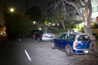
Over the weekend, destructive blasts that hit 90 mph in some areas were blamed for two deaths, toppled more than 600 trees and cut power to about 6,600 homes, mostly in the West Valley, authorities reported.
Residents hard hit by the first storms were wary of another round.
“If the winds pick up again, we’re out of here again,” said Steve Walker, a Woodland Hills resident who had two of his 180-foot Aleppo pines toppled over the weekend, crushing six cars and his garage in the 21300 block of Castillo Street.
“We had crews yesterday and today doing repairs from over the weekend,” Karen Shepard-Grimes, a spokeswoman for the Los Angeles Department of Water and Power, said Tuesday. But “we are still preparing for tomorrow,” she said, with extra workers on call to handle any power outages.
Earlier Tuesday, the Fire Department got a call about downed wires in Tujunga and a tree blown over in Chatsworth, but no injuries were reported, Humphrey said.
A fire broke out at what police said was an illegal methamphetamine lab in Chatsworth late Tuesday, but it was put out inside the building before the flames could reach the howling winds outside.
Firefighters extinguished the small stove-top fire about 4 p.m. in the 9600 block of Mason Avenue. The fire was reported by narcotics officers from the LAPD’s Devonshire Station investigating strange odors, Humphrey said.
Officers arrested two women and three men whose names were not yet released, according to LAPD spokesman Vince Aguirre.
Two uniformed officers and two detectives who breathed smoke from the lab were treated for respiratory problems and released from a local hospital, Aguirre said.
* BRUSH FIRE: Rancho Cucamonga blaze nears homes. A37
(BEGIN TEXT OF INFOBOX / INFOGRAPHIC)
Santa Ana Return
As San Fernando Valley residents clean up from last weekend’s hurricane force Santa Ana winds, the National Weather Service is forecasting more strong wind. Winds of 25 to 50 mph are predicted for Wednesday, with gusts to 70 mph below Southland passes and canyons. These gusty, dry winds are the result of several meteorological events and are part of a complex weather system that extends throughout the Western states.
High Pressure: A dome of arctic high pressure was building over the Great Basin on Tuesday.
Low pressure: A system of low-pressure counterclockwise winds developed off the California coast and also centered over the Gulf of Alaska on Tuesday.
****
How The Winds Get Fast and Dry
A) Fast: Wind gains speed as it is funneled through the narrow mountain passes and canyons.
B) Dry: The sinking air motion can cause humidity to go down to single digits.
****
Conditions for Strong Winds
* Jet Stream: Powerful Santa Ana winds need a strong jet stream occurring over Southern California. The jet stream guides storms and its position on Tuesday was right at the California/Nevada border.
* Air circulation: Air circulating clockwise in the high-pressure system moves west toward Southern California, becoming the northeasterly winds called Santa Anas.
Sources: UCLA Atmospheric Science Department; National Weather Service. WeatherData Inc.
Researched by JULIE SHEER / Los Angeles Times
More to Read
Sign up for Essential California
The most important California stories and recommendations in your inbox every morning.
You may occasionally receive promotional content from the Los Angeles Times.


