Southern California is in an unseasonably warm heat wave. How hot could it get where you are?

- Share via
Thursday and Friday are expected to be the hottest days this week across Southern California, as an unseasonably warm heat wave and Santa Ana winds continue to push temperatures higher, according to the National Weather Service.
Temperatures are expected to be in the 80s to 90s for the southern coasts and coastal plains, while it could reach between 85 and 100 degrees for the valleys and deserts, according to the weather service. It’s expected to be cooler, in the upper 70s and low 80s, along the central coast.
What are heat-related illnesses and how are they treated? Are they preventable or inevitable? We talked to health experts for the answers.
Santa Ana winds are expected to range between 25 and 40 mph Thursday and drop down to 15 to 25 mph Saturday.
The National Weather Service recommended that residents limit outdoor activities, especially during the hottest parts of the day, drink plenty of fluids, avoid caffeine and alcohol, dress in loose-fighting clothing and use extra caution with outdoor fires. People should also check that children, elderly people and pets are not left alone in vehicles.
A wind advisory has also been issued for the Santa Clarita Valley, Santa Monica Mountains, Interstate 5 Corridor and the Western San Gabriel Mountains until 3 p.m. Thursday. Northeast winds could range from 20 to 30 mph, with gusts up to 45 mph. Unsecured objects could be blown around and make driving more difficult.
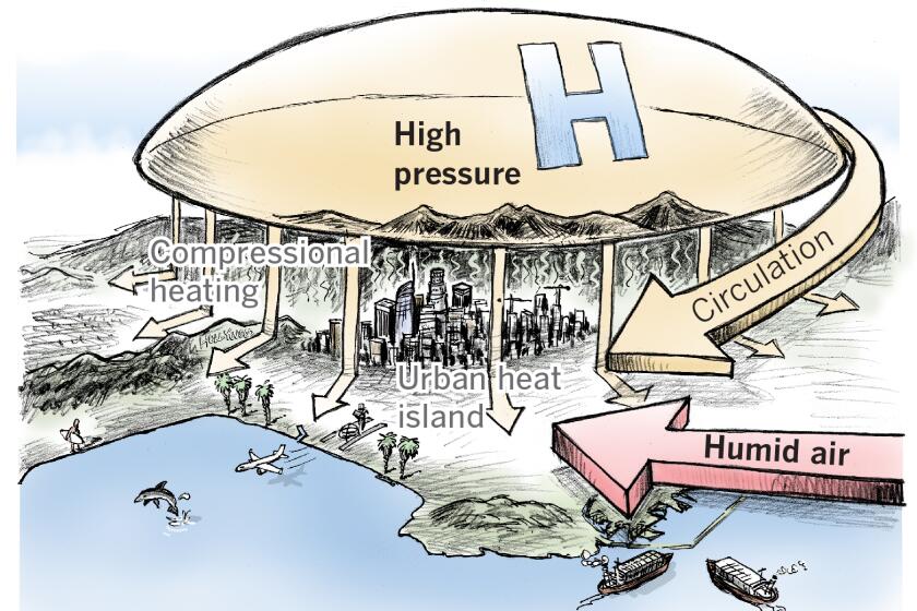
California’s worst heat waves arrive in a one-two punch — high temperatures combined with humid air from Baja.
Across the globe, September 2023 was the hottest September on record, according to a report from the Copernicus Climate Change Service, a climate change watchdog. There was an average global surface air temperature of 61.5 degrees Fahrenheit during September, which is 1.69 degrees above the 1991 to 2020 average for September and .92 degrees higher than the temperature of the last hottest September, which was recorded in 2020.
“The unprecedented temperatures for the time of year observed in September — following a record summer — have broken records by an extraordinary amount,” Samantha Burgess, deputy director of the Copernicus Climate Change Service, said in a statement.
August was also the warmest August on record, with the Northern Hemisphere experiencing its hottest meteorological summer yet, according to the National Oceanic and Atmospheric Administration.
More to Read
Sign up for Essential California
The most important California stories and recommendations in your inbox every morning.
You may occasionally receive promotional content from the Los Angeles Times.


