West Virginia’s West Fork Rail Trail follows streams through Allegheny Mountains
- Share via
DURBIN, W.Va. — The West Fork Rail Trail is one the sweetest rail trails in West Virginia.
It runs 23 miles from Durbin in Pocahontas County north to Glady in Randolph County in the heart of the Allegheny Mountains. It follows two streams: the north-flowing West Fork of Glady Fork and the south-flowing West Fork of the Greenbrier River. It owes its name to the two West Forks.
The result is a mostly flat trail in some of the most picturesque terrain of the 919,000-acre Monongahela National Forest. There is a slight descent from north to south, but that is barely noticeable. The elevation ranges from 3,130 feet down to 2,730 feet.
The trail offers a remote and wild feeling even though civilization is never too far away. It runs north to south just east of Cheat and Shavers mountains. It is popular with bicyclists, hikers, equestrians and, from December to at least mid-March, cross-country skiers.
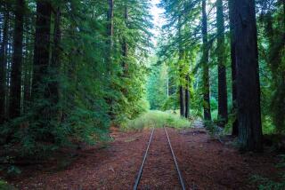
The trail runs next to the streams with hardwood forests on its slopes. There’s great fishing for stocked trout and swimming in numerous pools. You pass a few small farms, picturesque pasture lands, beaver ponds and wetland pockets. The trail is at its best when wildflowers are in bloom and when leaves are changing in the fall.
West Fork Road, a forest service road, parallels much of the trail and creates numerous loop opportunities. The trail itself is a combination of hard-packed dirt, stones, crushed gravel, cinders and rail ballast. You might even encounter old rail spikes. The U.S. Forest Service has worked to improve the decks on the old rail trestles to make them more passable for bicyclists.
West Fork is a no-frills trail with few amenities. There are no toilets or drinking water. You can camp overnight on public lands along the trail. Motorized travel on the West Fork Trail is prohibited.
You can access the trail’s southern terminus in Durbin off U.S. 250 and Pocahontas Street. There is a trail sign, a kiosk and parking for a few cars little else. The northern terminus is at Glady.
Previously, the trail ended at Greenbrier Junction, an isolated rail junction about four miles southwest of Glady. That section was closed to trail users because of safety concerns about an old tunnel.
The rail line was built in the early 1900s by the Coal and Iron Railway Co. and its president, Henry G. Davis. It completed the rail line from Elkins to Durbin in 1903 where it connected with the Chesapeake & Ohio Railway.
Later the Coal and Iron Railway was sold to the Western Maryland Railway Co. At that time, the rail company had 46.4 miles of tracks and 5.8 miles of sidings where timber was loaded off Cheat Mountain and the upper Greenbrier River valley. The company began hauling coal when timber shipments started to decline.
The corridor, later owned by CSX, was abandoned and purchased in 1986 by the Trust for Public Land, a national land conservancy group, then sold to the forest service.
About 3.5 miles south of Glady, the West Fork Trail intersects with the High Falls Trail. It is a 3.2-mile hike to the west to one of the most popular and accessible waterfalls in the national forest. The Allegheny Trail follows that route, too. You can access High Falls Trail off the forest service road.
High Falls is a 100-foot-wide horseshoe-shaped waterfall with an 18-foot drop on Shavers Fork of the Cheat River. It is commonly called one the prettiest waterfalls in West Virginia, although it does not match Blackwater Falls near Davis.
The hike to the falls will gain about 1,400 feet. The falls are only accessible to hikers and rail passengers.
For West Fork information, call 304-456-3335 or go to https://www.fs.usda.gov/main/mnf/home.
There is talk of linking the West Fork Trail with the bigger and better-known Greenbrier River Trail. A 16-mile gap between Durbin and Cass would have to be developed to create a 117-mile trail.
The Greenbrier River Trail stretches 78 miles along the longest free-flowing river in the eastern United States, running through a picturesque and surprisingly wild valley, next to a pretty stream, through forests and past open fields. It runs from Cass, a onetime historic timber boom town, south to Caldwell at Interstate 64 near Lewisburg.
Backpacker magazine has called the Greenbrier River Trail one of the Top 10 hiking trails in the United States. It has also been designated a federal Millennium Legacy Trail, one of 50 in the United States.
It is one of the best long-distance bike-and-hike trails in the East, right up there with the 150-mile Great Allegheny Passage in Pennsylvania and Maryland and the 184.5-mile Chesapeake & Ohio Canal National Historic Park in Maryland.
Fat-tire bicyclists outnumber hikers on the Greenbrier trail, managed by the state of West Virginia. It is also used by equestrians and cross-country skiers. It is mostly hard-packed gravel, but five miles from Marlinton to Buckeye have been asphalted.
You can pedal a section on a day trip, or bike-camp and cover the entire rail trail in two to three days. You can find cottages and bed and breakfasts close to the trail for overnight lodging.
The trail a long and skinny state park is generally flat with a grade of less than 1 percent. It offers a rustic, in-the-middle-of-nowhere feel. For trail information, call 304-799-7416 or 800-CALL-WVA or go to https://www.greenbrierrailtrailstatepark.com.
Sleepy Durbin off U.S. 250 is also home to the Durbin Rocket, with a historic rail depot and a rail-and-trail store.
The Durbin & Greenbrier Valley Railroad offers departures from depots in Durbin and Elkins from April through December. Four excursions are offered, along with special excursions: comedy club trips, wine-and-roses romantic excursions, astronomy trips, murder-mystery trains, ramp celebrations, rail cookouts and a Christmas-themed Polar Express trips.
The state of West Virginia is working with railroad owner John Smith to explore a new option: a 90-mile rail loop in the mountains east of Elkins.
Under that plan, one section of now-closed rail would be abandoned to create a new trail, and those tracks would be installed along the West Fork Rail Trail between Durbin and Glady. The project would take 18 to 24 months to complete once the funds are found and the plan wins approval.
For railroad information, call 1-877-MTN-RAIL (686-7245) or 304-636-9477. You can also go to https://mountainrailwv.com.
The Allegheny Trail runs north to south through West Virginia. It runs through four state parks, two state forests and three national forests. You will find it outside of Durbin. For information, go to https://www.wvscenictrails.org.
You can buy a 208-page guide to the Allegheny Trail for $27 plus $3 for shipping and handling. Contact Doug Wood at 304-466-2724 or Diane Anestis at 304-755-0440.
Pocahontas County offers some of the best mountain biking in West Virginia. For travel information, call 800-336-7009 or go to https://www.NaturesMountainPlayground.com.
(c)2014 Akron Beacon Journal (Akron, Ohio)
Visit the Akron Beacon Journal (Akron, Ohio) at https://www.ohio.com
Distributed by MCT Information Services
PHOTOS (from MCT Photo Service, 202-383-6099): UST-WVIRGINIA-RAILTRAIL
More to Read
Sign up for The Wild
We’ll help you find the best places to hike, bike and run, as well as the perfect silent spots for meditation and yoga.
You may occasionally receive promotional content from the Los Angeles Times.


