Doin’ the Dunes at Stovepipe Wells
- Share via
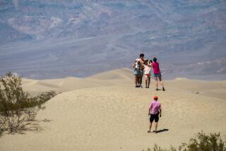
A 14-square-mile field of dunes and some bizarre geology are attractions of a visit to the Stovepipe Wells area of Death Valley.
Hiking the dunes is most fun in the cooler morning and late afternoon. At those hours, the dunes are most photogenic, too; the light is softer, the shadows longer.
Death Valley’s dunes are formed in much the same way as the mega-dunes in the deserts of the Middle East and North Africa. Nature’s recipe for making dunes is fairly simple: a source of sand, wind to separate the sand from gravel, more wind to roll the sand along into drifts, and still more wind--perhaps in the form of a back draft--to keep the dunes in place.
Death Valley’s dunes lie between Towne Pass on the west and Daylight Pass to the east; there’s quite a sand-laden draft between the two passes. These dunes are sub-barchan, or crescent-shaped. The sand dunes actually consist of tiny pieces of rock, most of them quartz fragments.
The slip face of the dunes (away from the wind) is very steep, but never steeper than 34 degrees. This is known as the angle of repose: If the dune is steeper than this, a slide occurs, thus reducing the angle a degree or three.
As you hike the dunes, you’ll notice blow sand (loose, very fine particles) piled on the leeward side of plants; these piles are known as sand shadows.
Near the dunes are some weird natural features. Those surrealistic-looking cornstalks you see across California 190 from the dunes are actually clumps of arrowweed. The Devil’s cornstalks are perched on wind- and water-eroded pedestals.
Fringing the dunes are expanses of dry mud that have cracked and buckled into interesting patterns. These mud sink areas and the edges of the dunes themselves are good places to look for the tracks of the few desert creatures able to survive in this harsh environment--most notably rabbits and kangaroo rats.
Start this hike by taking California 190 six miles east of Stovepipe Wells village to the signed turnoff for the dunes. Turn north on the good dirt road and follow it a short distance to the dune picnic area.
Just up the dirt road is the historic site of Stovepipe Well. During pre-auto days, old stove pipes were sunk into the sand to form walls for a well. An old hand pump marks the spot of this once-famous water hole.
Your hike into the dunes is exactly what you make of it--short or long, a direct or indirect route to the higher sand formations. Figure four miles maximum to climb up, down and around the taller dunes and then return. Remember that “doing the dunes” means a two-steps-forward-one-step-backward kind of hiking, so pace yourself accordingly.
Dune Trail
WHERE: Stovepipe Wells area, Death Valley National Monument
DISTANCE: 2-4 miles round trip.
TERRAIN: 14 square miles of sand dunes.
HIGHLIGHTS: Hiking among the fun and photogenic dunes.
DEGREE OF DIFFICULTY: Easy.
PRECAUTIONS: Sand surfaces can be very hot; wear shoes.
FOR MORE INFORMATION: Contact Superintendent, Death Valley National Monument, Death Valley, Calif., 92328, (619) 786-2331.
More to Read
Sign up for The Wild
We’ll help you find the best places to hike, bike and run, as well as the perfect silent spots for meditation and yoga.
You may occasionally receive promotional content from the Los Angeles Times.


