12 homes evacuated in Rolling Hills Estates after ground shifts

- Share via
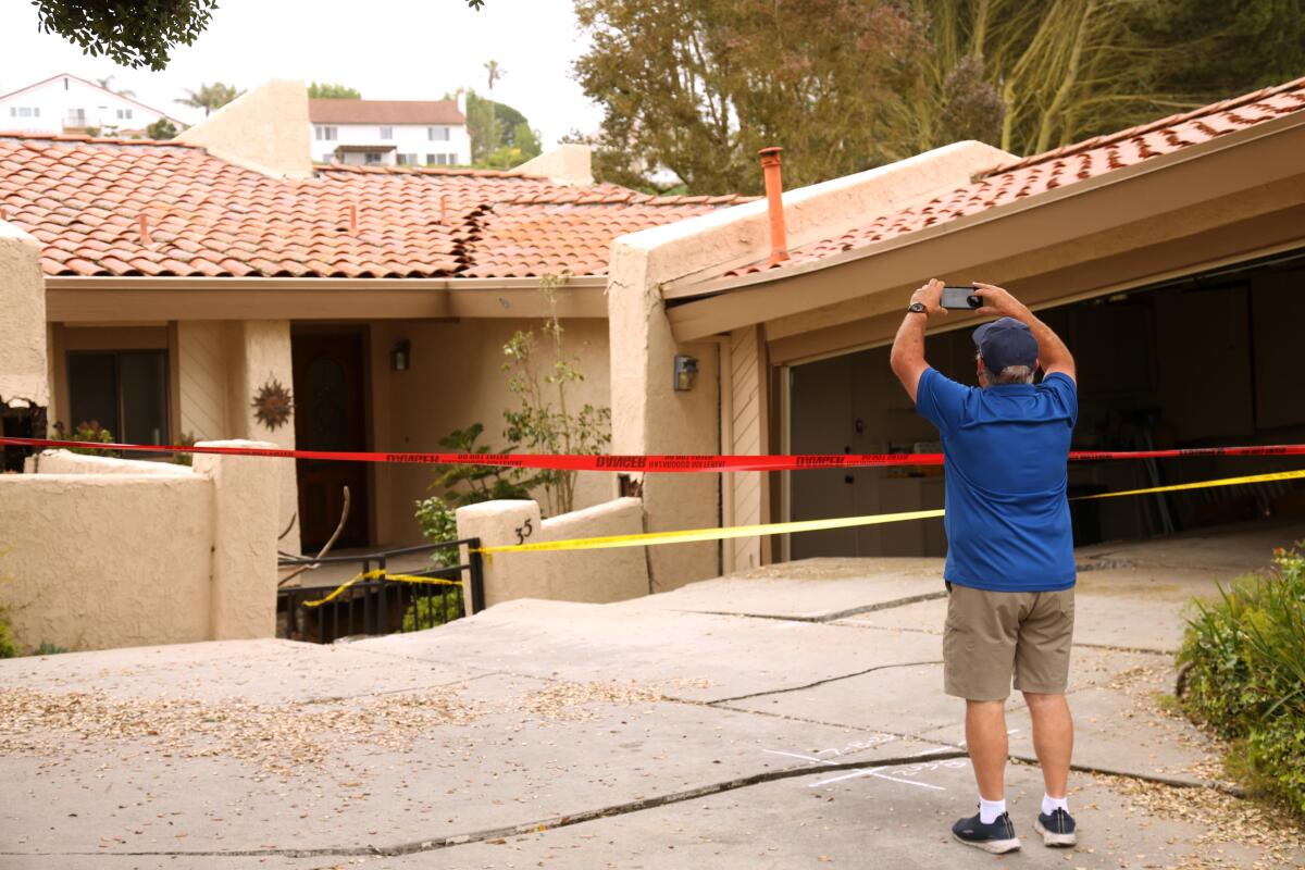
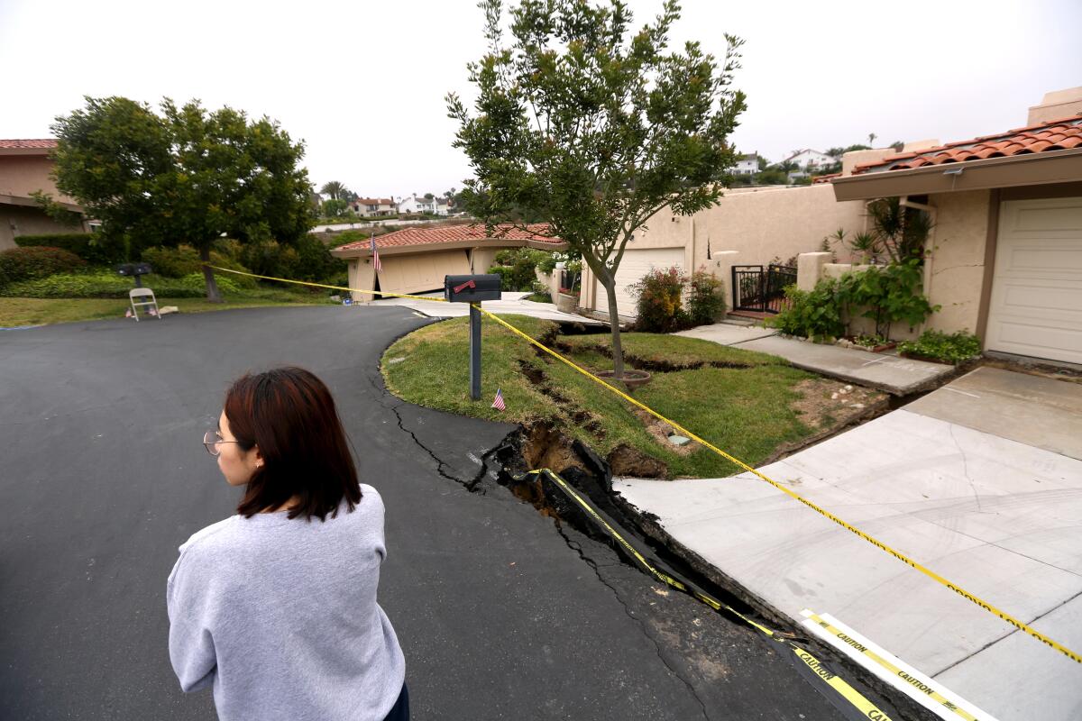
Twelve homes were evacuated in Rolling Hills Estates on Saturday night after the ground shifted, leaving major cracks and some structures “visibly leaning,” officials said.
Firefighters and investigators were sent about 4 p.m. Saturday to Peartree Lane, where hilltop homes overlook a canyon, officials said. The community is on the southwestern side of the Palos Verdes Peninsula.
For the record:
12:44 p.m. July 11, 2023A previous version of this story said the Rolling Hills Estates neighborhood affected by the slides is on the northern side of the Palos Verdes Peninsula. It is in the southwestern part of the peninsula.
Cracks in the homes were visible on the inside and outside, said Los Angeles County Fire Captain Chiyoshi Hasegawa. About 16 people were evacuated, he said, and utilities were shut off to reduce the risk of fire.
Los Angeles County Supervisor Janice Hahn, whose district includes the city, said she was notified Saturday night about the land movement and the evacuation.
Residents of the affected homes “were told they had 20 minutes to get their belongings and get out,” Hahn said at a noon press conference Sunday at the site, where she was joined by Rolling Hills Estates Mayor Britt Huff and officials from the county fire and public works departments.
She said a fissure, or crack in the earth’s surface, was winding its way between the affected homes.
“We believe many of these homes will fall into the canyon sooner than later,” Hahn said.

City and county officials said Sunday that it is too early to speculate on what caused the ground to shift and that the matter is under investigation. They said they are monitoring other homes in the neighborhood for movement.
“This neighborhood was built in 1978 and it’s been solid for 45 years,” Huff said. “So we’re very much in shock by what is happening here.”
Pete Goodrich, a building official with the city, said geologists will inspect the site and decide what can be done. He said there was substantial damage to the homes.
The land movement “could be due to the extensive rains that we’ve had .... but we don’t know,” Goodrich said of recent winter storms.
Hahn said she could understand the fears of the affected homeowners.
“I haven’t seen anything like this in my career,” she said. “To think that these homes were intact yesterday afternoon and today to hear them creaking.... These homes are going to fall.”
David Zee, a former Torrance resident who said he moved into one of the 12 houses two months ago, told Hahn and the other officials that his family was devastated by what was happening.
“We thought this would be our forever house,” he said. “Maybe it still will be, but I’m just concerned. I’m usually not emotional but, you know, it’s our house.”
Mimi Borg has owned a home for six years across the street from one of the evacuated homes. She said her house has not been damaged, but her gas has been shut off indefinitely amid concerns that the problem could spread.
On Sunday morning, she surveyed the house across the street with a Spanish-style roof that had sustained significant damage.
“Last night I was out for a walk, and there was just a crack on the driveway and the wall, and now it’s 100 times worse,” she said. “We’re just hoping it doesn’t spread to us. I am worried. I have all of my stuff packed, all ready to go if they tell me to go.”
Ferry Mafinezam of Canada was visiting her sister a short walk up the hill from the evacuated homes. She said she felt an earthquake in the area last week and that her sister is “concerned” her home could be damaged.
“About a week ago I woke up to an earthquake just shaking the house,” Mafinezam said. “Now this morning I walked up and saw this.”
Geologists are expected to survey the land to determine what will happen to the homes.
The Palos Verdes Peninsula has long been prone to landslides, and the most dramatic one is affecting Portuguese Bend, an area on the south side named after a whaling operation, now known for its natural beauty and native vegetation.
A dormant landslide complex has shaped the area for hundreds of thousands of years. It was reactivated 67 years ago and is threatening to destroy homes and infrastructure.
The geological phenomenon has hit a 240-acre area particularly hard over the last seven decades, causing fissures to open in the earth and homes to strain, buckle and drift, sometimes onto adjacent properties.
City officials are planning to mitigate the landslide before it’s too late.
“Something catastrophic is imminent,” Ara Mihranian, a city planner, told The Times in March. Since being named city manager in 2019, he has made slowing the landslide a primary focus.
The Portuguese Bend landslide was triggered in summer 1956 — nearly two decades before Rancho Palos Verdes became a city — when a Los Angeles County road crew was constructing an extension of Crenshaw Boulevard that would run from Crest Road to Palos Verdes Drive South.
The crew dug up thousands of tons of dirt for the project and dropped it on top of the ancient landslide zone, which hadn’t moved in 4,800 years. The extension was never completed, but the weight and movement of the dirt shifted the balance of the earth enough to reactivate the slide, sending the land into a slow-motion descent toward the sea.
In recent years, the landslide’s harm has been more incremental than the initial destruction in 1956 that tore up a community clubhouse and 130 area homes. City officials said the land moves sometimes horizontally, sometimes vertically. Sometimes inches, sometimes feet.
Officials said it moves at a pace of roughly eight feet, in a southwesterly direction, per year. Over the last 15 years, sections of land have moved anywhere from 100 to 225 feet horizontally and dropped eight to 18 feet vertically.
The most noticeable damage is dealt to Palos Verdes Drive South — the road that winds along the coastal cliffs — warping it into a crooked, hilly mess with dips that make your stomach jump. The city has to send a crew once a month to fill cracks, maintenance that costs roughly $1 million per year.

Times staff writer Jack Flemming contributed to this story.
More to Read
Sign up for Essential California
The most important California stories and recommendations in your inbox every morning.
You may occasionally receive promotional content from the Los Angeles Times.


