The great El Niño of 1997-98, and what it means for the winter to come

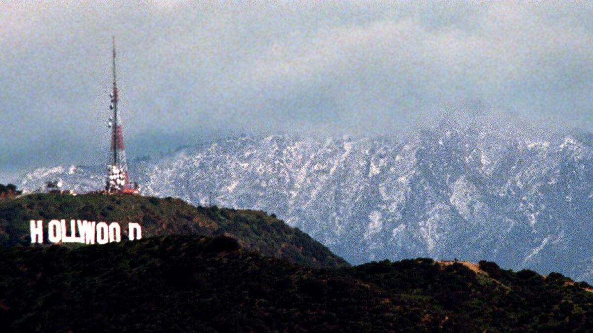
Snow forms a backdrop to the Hollywood sign after an El Niño storm in 1998.
- Share via
It started in October 1997 in Mexico, when a hurricane fueled by El Niño slammed into Acapulco, causing massive flooding and hundreds of deaths.
A few weeks later, rain started hitting Orange County. Then, in December, in the course of just 24 hours, the skies opened up over Orange County in what meteorologists described then as the wettest, most intense single-day deluge in more than a century.
More than 7 inches fell in parts of south Orange County in one day. Mobile home parks in Huntington Beach flooded. Rescuers were forced to use inflatable boats and a catamaran to scoop up residents. Mudslides destroyed hillside homes. Major roads were made impassable by debris.
And that was just the beginning. El Niño-fueled rains began striking Los Angeles in January and intensified. Over the next few months, a relentless string of storms caused havoc, washing away roads and railroad tracks, overflowing flood control channels, causing 17 deaths and more than half a billion dollars in damage in California. The toll was far worse in Mexico, where Tijuana and other cities faced crippling flooding.
The importance of the storms of 1997-98 is now coming into focus as scientists expect the latest El Niño to strengthen and hit Southern California with a vengeance.
The weather phenomenon developing in the Pacific has the potential to become one of the most powerful on record, as warming ocean waters surge toward the Americas, setting up an atmospheric pattern that could bring once-in-a-generation storms this winter to drought-parched California.
Here’s a guide to understanding the last major El Niño as California prepares for this one.
What was the worst time for the 1997-98 El Niño in Southern California?
It was February 1998. With 13.68 inches of rain in downtown Los Angeles that month — almost a year’s worth of rain — it was the wettest February since records for L.A. began being kept more than 130 years ago, said Bill Patzert, climatologist for NASA’s Jet Propulsion Laboratory in La Cañada Flintridge.
Some of the worst damage and many of the deaths were recorded at the end of month, when the land couldn’t absorb any more water.
The month’s last storm killed at least half a dozen people across the region. Two California Highway Patrol officers died in San Luis Obispo County after their car fell into a massive sinkhole as a river eroded a highway. Two Pomona College 19-year-olds heading to class were killed when a eucalyptus tree slammed into their sport utility vehicle.
The same storm also aimed a devastating mudslide into homes in Laguna Beach. Glenn Alan Flook, a lanky, athletic 25-year-old, had taken refuge in a neighbor’s home when it was struck by mud. He was thrown through a window as the room collapsed; his body was found wedged beneath a mobile home 50 yards downstream.
There were actually only a few storms that month, none of which was historically big. But added together, over such a small period of time, they were devastating.
“In that February of 1998 alone, we had four big storms and two small storms, and we got almost a year of rain in one month,” Patzert said. “So February looked like something that should’ve been spread over the entire winter.
“Things get saturated,” he said, “and the soil can’t absorb it.”
What kind of El Niño are we looking at this year?
Scientists say this year could produce one of the strongest on record.
During strong El Niños, the subtropical jet stream that ferries wet storms over the jungles of southern Mexico and Central America moves northward, putting a train of storms over Southern California and the southern United States, Patzert said.
Only exceptionally strong, “Godzilla” El Niños historically were powerful enough to shift the entire jet stream to cover all of California, giving the south double its rainfall and the north double the snowpack, Patzert said. Those severe El Niños hit in 1982-83 and 1997-98.
Covering the mountainous north with snow is essential to replenishing the water supply, because that’s where California’s largest reservoirs are located. They need to be fed at a gentle pace by snow melting through the spring and summer.
Right now, this year’s El Niño has been at moderate strength, said Mike Halpert, deputy director of the National Weather Service’s Climate Prediction Center, and getting stronger.
As of Aug. 12, the sea-surface temperatures at a benchmark location west of Peru were at 3.6 degrees Fahrenheit above average, the highest since this El Niño was officially declared in March.
The temperatures have been closely tracking what happened in the summer of 1997, which led up to the strongest El Niño on record.
Why could El Niño break the relentless weather pattern over the last few years, which dried up California and buried Boston in snow?
California’s drought has been worsened in recent years by a mass of relentless high pressure sitting atop the Gulf of Alaska, scaring off the cool, wet storms ferried by the jet stream away from the West Coast.
“It moved the jet stream into northern Canada, swooping it into the Midwest and Boston,” Patzert said. In California, “we were left high and dry, and Boston got our rain in the form of blizzards.”
The high pressure pushing on the surface of the northeastern Pacific Ocean has caused it to heat up, forming a “blob” of warm water. Some scientists say the blob further reinforces the drought-worsening “ridiculously resilient ridge” of high pressure.
Why are scientists more confident this El Niño will be strong, when previous forecasts have fizzled?
The Pacific Ocean this summer is warmer than it has been since the record-breaking El Niño that formed in 1997. In a benchmark location of the Pacific off Peru last month, the temperature was the highest it has ever been for the month of July since the summer of 1997.
Is it possible El Niño could fizzle?
There’s one more ingredient this El Niño would require to get “on steroids” — the wind changing directions.
For El Niño to work, the Pacific Ocean needs to warm up west of Peru. That can only happen in earnest if the normal direction of winds along the equator — east to west — changes. The normal direction of the winds heats up the western Pacific, which is why the beaches of Indonesia and Malaysia are so tempting. A collapse of those winds allows warm waters to surge to the Americas, where they need to be for El Niño to strengthen.
The winds have recently weakened and even reversed in some locations. But they haven’t yet done so in a sustained manner, Patzert said, like they did in 1997.
If the winds unexpectedly start resuming in the normal direction, this El Niño may become second-rate.
That would be a big problem for forecasters. Only very strong El Niños have been strong predictors of heavy rainfall for California. Mediocre El Niños have a mixed track record.
“If it’s a Godzilla El Niño,” Patzert said, “it’s the best forecasting tool ever.”
“But if it’s not a Godzilla, it’s a pretty shaky forecasting tool. Because we know pretty modest El Niños can give us pretty dry winters,” Patzert said.
If those trade winds don’t collapse, he added, “Godzilla could become El Gecko.”
ron.lin@latimes.com; christine.mai-duc@latimes.com
More to Read
Sign up for Essential California
The most important California stories and recommendations in your inbox every morning.
You may occasionally receive promotional content from the Los Angeles Times.


