‘Life-threatening’ storm to slam Southern California beginning Sunday, last for days

- Share via
A dangerous, intense storm will move into Southern California on Sunday, bringing the potential for widespread flooding, power outages and debris flows.
Officials are urging caution during the most treacherous periods of the storm Sunday and Monday.
“We continue to see a high risk for life-threatening and damaging flooding across the region, as well as large waves and coastal flooding for many coastal areas,” Robbie Munroe, a meteorologist with the National Weather Service in Los Angeles, said during a webinar Saturday.
The worst of the heavy rain and wind is expected Sunday to Monday, but additional rain after that could exacerbate hazards because of already wet conditions, he said.
Motorists are advised to change travel plans to avoid potentially dangerous roads and move parked cars out of low-lying areas. Everyone should ensure they have enough supplies to weather potential power outages caused by downed trees or power lines.

Hurricane Hilary is moving toward Southern California. Here’s how to prepare and stay safe before and during the storm, heavy rain and potential flooding.
The forecast
Weather officials are expecting 3 to 6 inches of rain across Southern California’s coasts and valleys and 6 to 12 inches in mountains and foothills. Many places, including urban areas, are expected to see rainfall totals on the high end of that range; Munroe described this as “very concerning” because the ground is still moist from Thursday’s atmospheric river storm.
Santa Barbara, Ventura and Los Angeles counties are expected to see some of the worst flooding.
The weather service is predicting 2 to 4 feet of snow at elevations above 7,000 feet, 10 to 20 inches between 6,000 and 7,000 feet and up to 10 inches between 5,000 and 6,000 feet. Residents of mountain areas should prepare for the potential of being stranded for several days, forecasters said.
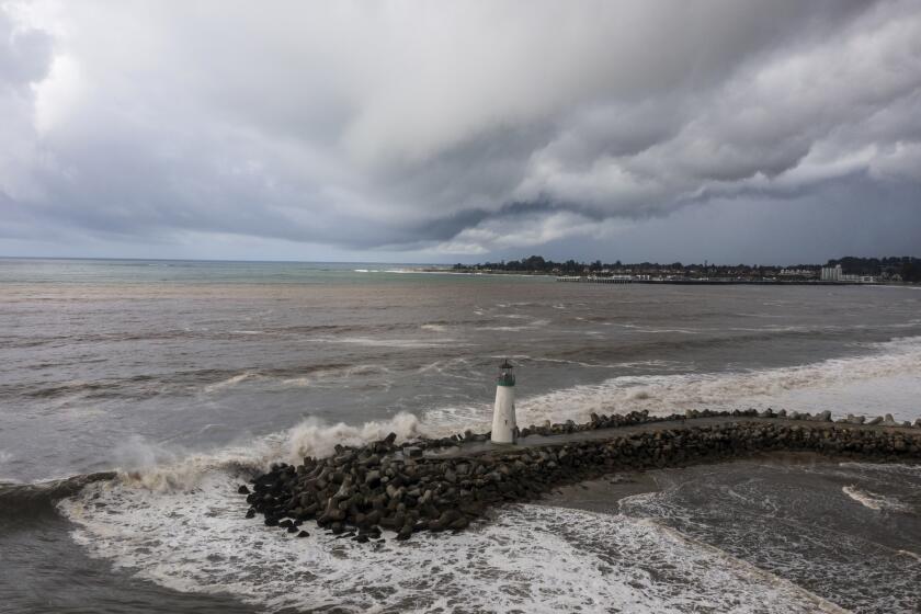
In addition to rain and snow, “high surf, large battering waves” could contribute to coastal flooding, according to Ryan Kittell, a National Weather Service meteorologist in Oxnard. And if the pounding waves aren’t enough, “potentially deadly rip currents” should keep everyone out of the water.
The storm’s effects will be felt statewide, with forecasts showing more than 3 inches of rain possible from the Mexico border to the Bay Area from Sunday through Tuesday — well over the average for the entire month in many areas.
“This is not an ordinary winter storm,” said Daniel Swain, a UCLA climate scientist, predicting that different parts of the state would be hit differently.
The strongest wind gusts along the California coast are likely to occur between northern San Luis Obispo County and San Mateo County, he said. The area could see gusts over 70 mph and even 80 mph, Swain said.
There’s also the potential for lightning across a wide swath of the state from Lake Tahoe to Mendocino to downtown L.A.. “That is not typical for this part of the world,” he said.

Heavy, sustained rains are forecast across Southern California on Sunday and Monday, bringing almost double Thursday’s rain with damaging flooding possible.
Timeline
Saturday: Rain will begin in the evening in Northern California, primarily along the coastal Bay Area, before heading south.
Sunday: Heavy rainfall is expected to begin in San Luis Obispo and Santa Barbara counties, moving into Ventura and Los Angeles counties by late in the day. Strong bands of sustained rainfall will create widespread flood threats. The highest risk of flooding will be Sunday night through Monday evening.
Monday: The storm is expected to continue, bringing added danger from sustained rainfall on already saturated ground.
Tuesday: Light rain is expected, with a potential for isolated thunderstorms bringing downpours.
Wednesday to Friday: Lingering showers are forecast.

Heavy rainfall moved across Southern California on Thursday, causing flooding, road closures and some water rescues. But all eyes are focused on the next, stronger storm.
Conditions:
- A flood watch has been issued for across the region beginning Sunday.
- Wind gusts up to 90 mph are forecast for mountain areas.
- Expect downed trees and power lines and dangerous coastal conditions.
- Snow levels should drop to 6,500 feet Sunday and 4,000 feet Wednesday.
There is the potential for avalanches in mountain areas.
Warm ocean waters are upping the odds of significant downpours and offering a preview of the state’s future in a warming world, experts say.

Danger zones
Officials say residents should expect street flooding and mudslides in vulnerable areas.
Thunderstorms and heavy rain bands could bring flash flooding. River and creek flooding is also possible in some areas.
The California Governor’s Office of Emergency Services has deployed personnel and resources to many areas in the path of the storm, including more than 550 firefighters and 19 swift-water rescue teams in 19 counties, officials said. Two million sandbags have been pre-positioned across the state.
Ventura County
The sheriff on Saturday issued issued evacuation orders and warnings. Residents of Matilija Canyon and Camino Cielo in unincorporated Ojai were ordered to vacate from 5 p.m. Saturday to at least 5 p.m. Sunday; others were warned that they may have to do so. The sheriff’s office also told residents of La Conchita to prepare for the possibility of landslides or debris flows. The hillsides above the community have received nearly 4 inches of rain over the last two weeks and may see an additional 3 to 5 inches over the next five days, the sheriff’s office said.
A shelter will operate at Ventura College gymnasium at 4667 Telegraph Rd. starting Sunday morning.
Santa Barbara County
Officials are urging residents to stay away from rivers, creeks, flood-prone, low-lying areas and wildfire burn scars, which can turn into dangerous mud and debris flows during heavy rains. Beaches, bluffs and harbor areas may see coastal flooding and erosion, and residents and visitors are advised to stay away.
Evacuation orders were issued for properties along waterways associated with the Thomas, Cave and Alisal burn areas and, in the city of Santa Barbara, those in the vicinity of Sycamore Creek, from Stanwood Drive to parts of Ninos Drive.
Los Angeles County
Officials are keeping a close eye on the Palos Verdes peninsula, which saw devastating land movement last summer and a mudslide Thursday, as well as Long Beach and areas along the San Gabriel Mountains, according to Emily Montanez, associate director with the L.A. County Office of Emergency Management.
“We’re always keeping an eye on that area, especially with recent burn scars like in Duarte, with the Fish fire,” Montanez said. “In burn scar areas, within three years post-fire, there’s always a chance for mud and debris flow.”
The county’s Public Works Department is working to clear storm drains and flood control channels in preparation for an influx of water, she said. The agency is expected to issue phased warnings for areas in the path of the storm. That may include evacuation notices in Duarte, Azusa, the Santa Clarita Valley and other at-risk areas.
Montanez added that the county is positioning Sheriff’s Department officials, as well as fire and emergency response personnel, in case door-to-door evacuation notices are warranted. The county is also readying an outreach team for unhoused populations, she said.
L.A. Mayor Karen Bass urged residents to monitor the storm and be mindful of extreme weather warnings.
“We know the severe impact that weather can have on our communities, and we are making sure Los Angeles is prepared on behalf of our residents, including the unhoused Angelenos living on our streets, to get through this storm,” she said.
By Saturday afternoon, the threat of severe weather Sunday had prompted NASCAR to reschedule race events planned for the L.A. Memorial Coliseum. The doubleheader — the NASCAR Cup Series’ Busch Light Clash and NASCAR Mexico Series’ King Taco LA Batalla — was moved to 5 p.m. Saturday from 5 p.m. Sunday.


Sign up for Essential California
The most important California stories and recommendations in your inbox every morning.
You may occasionally receive promotional content from the Los Angeles Times.


More From the Los Angeles Times


Podcasts

In this episode, we discuss the history here, what lessons were learned — and not — and how that can inform what we we do this time around as we attempt to rebuild Altadena and the Pacific Palisades.

Alexis Linkletter & Madison McGhee unpack the chaotic Justin Baldoni vs. Blake Lively lawsuit, separating fact from fiction, and its career impact.

Sammy Roth visits Ioneer’s proposed Rhyolite Ridge mine in Nevada with managing director Bernard Rowe, who details responsible lithium/boron extraction and Tiehm’s buckwheat protection.


